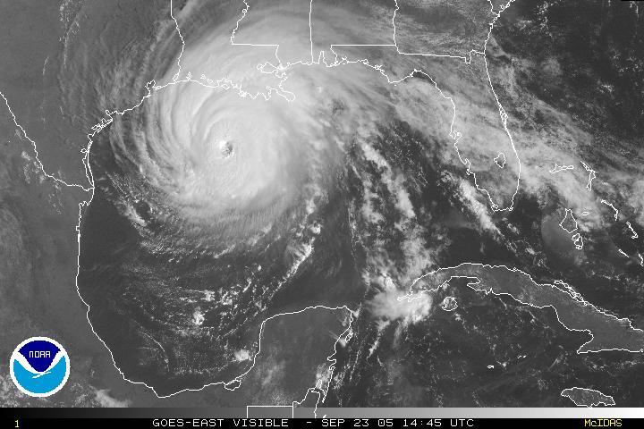
Hurricane Rita Photos, Sep. 23, 2005
http://educate-yourself.org/cn/cnnhurricaneritaenlargedphoto22sep05.shtml
(Use the latest posted image on top for a print out copy. Right click over the image and select"view this image" with you left mouse button. The image will come up on a new page. Print out that page)
Click
this link for instructions on how to mitigate this Hurricane with focused intent
(http://educate-yourself.org/cn/cnnhurricanerita22sep05.shtml)
See the latest Hurricane Rita Dowse from Philip Ledoux:
Hurricane
Rita Update Dowse (Severe Tornado Threat Sep. 22, 2005)
http://educate-yourself.org/pnl/hurricaneritaupdatedowse22sep05.shtml
Sep. 23, 2005 12:45 PM EDT Max. Winds 135 mph (CNN)
Click this link for earlier satellite and radar map photos of Hurricane Rita posted on Sep. 22, 2005
From: "Lou" <ReikiLou@Yahoo.com>
Date: Sun Aug 28, 2005 1:34 pm
Subject: 'the no storm' & 'the storm' reikilou
Follows are some links for weather satellite pic...quite useful
for visualizing.
*******************
NOAA's Most Popular Weather Web Sites
http://www.nws.noaa.gov/pa/popular_weahter_webs.php
Satellite maps of southeast US region (Gulf of Mexico)
http://www.ssd.noaa.gov/PS/TROP/DATA/RT/GMEX/VIS/20.jpg
* Aviation Weather Center
Aviation warnings and forecasts of hazardous flight conditions at all levels
within domestic and international air space.
http://aviationweather.noaa.gov/
* Climate Prediction Center
Monitors and forecasts short-term climate fluctuations and provides information
on the effects climate patterns can have on the
nation. http://www.cpc.ncep.noaa.gov/
* Hydrometeorological Prediction Center
Nationwide analysis and forecast guidance products out through seven days.
http://www.hpc.ncep.noaa.gov/
* National Climatic Data Center
Manages the Nation's resource of global climatological in-situ and remotely
sensed data and information to promote global
environmental stewardship; to describe, monitor and assess the climate; and
to support efforts to predict changes in the Earth's environment. Provides certified
weather data.
http://www.ncdc.noaa.gov/oa/ncdc.html
* National Oceanic and Atmospheric Administration
Agency of the U.S. Department of Commerce that is dedicated to enhancing economic
security and national safety through the prediction and research of weather
and climate-related events and providing environmental stewardship of our nation's
coastal and marine resources.
http://www.noaa.gov/
* National Weather Service
Weather, water and climate forecasts and information for the United States and
its territories.
http://www.nws.noaa.gov/
* NOAA Weather Radio All-Hazards
Immediate and reliable broadcasts of official weather and non-weather related
alerts and information from local National Weather Service Forecast Offices
to the public.
http://www.nws.noaa.gov/nwr/allhazard.htm
* Ocean Prediction Center
Weather warnings and forecasts out to five days for the Atlantic and Pacific
Oceans north of 30 degrees North.
http://www.opc.ncep.noaa.gov/
* Space Environment Center
Space weather alerts and warnings for disturbances that can affect people and
equipment working in space and on earth.
http://www.sec.noaa.gov/index.html
* Storm Prediction Center
Tornado and severe thunderstorm watches for the contiguous United States along
with a suite of hazardous weather forecasts. Technical discussions on the cause
and impact of hazardous winter weather, excessive precipitation, and non-severe
thunderstorms. http://www.spc.noaa.gov/
* Tropical Prediction Center
Includes the National Hurricane Center and provides forecasts of the movement
and strength of tropical weather systems and issues watches and warnings for
the U.S. and surrounding areas.
http://www.nhc.noaa.gov/
http://www.nws.noaa.gov/pa/popular_weahter_webs.php